Between Arica and our final destination lie a stunning 4000 miles, which make Chile the longest country in the world. This makes Chile a country of extremes. Our journey has covered extraordinary different places; from deserts to glaciers. According to the advise of former Chile cyclists the wind direction is mostly West (at least in windy Patagonia it is), which made us decide to cycle from north to south. Something we didn't regret. The most northern airfield in Chile is Arica and that's where we started our endeavor. The link in the column on the right shows our latest location en how many kilometers we have cycled in Chile.
_____________________________________
"Between Arica and our final destination lie a stunning 4000 miles, which make Chile the longest country in the world"
_____________________________________
From Arica to Puerto Williams we have travelled through the following provinces:
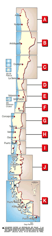
Tarapaca (A) - Antofagasta (B) - Atacama (C) - Coquimbo (D) - Valparais0 (E) - Maule (F)- El Biobio (G) - Araucania (H)- Los Lagos and Chiloé (I) - Coihaique (J) - Tierra del Fuego (K)
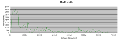
Click the links of the provinces to find out more about the exact route (with satellite images) and the region, like for instance some special destinations we visited, or possibly some mountainbiketrails we explored. You can also check a height profile of the entire tour by clicking the graph below.
_____________________________________
"... up to now it's impossible to cycle the complete length of Chile ..."
_____________________________________
Notice that up to now it's (nearly) impossible to cycle the complete length of Chile without having to take a bypass through Argentina. That's why we had to choose to either take a boat to the isle of Chiloé or to take a route into Argentina (see map I). We preferred to stick to Chile and headed for Chiloé by ferry from Pargua. Besides, the distance we cut off in a north-south direction is negligible. Because getting round the southern ice cap on the chilean side is not yet possible, our route also includes the ruta 40 from El Chaltén down to El Calafate and eventually Cerro Castillo (check map J and K). To get to El Chaltén we took a ferry from Villa O'Higgins that takes you to Candelario Mancilla. Luckily, staying on the Argentinian side means it's far easier to visit the Perito Moreno glacier. Finally, getting on to Tierra del Fuego means entering Argentina once again. From there we had to cross the Beagle Canal from Ushuaia (see map K) : again this meant alternative transport (boat) and travelling through a country other than Chile; forgive us for these impurities.
